Alex Bikes
Ottawa bike politics.
Why I’m so enraged about parking in a bike lane
Posted by on August 21, 2017
There isn’t a centimetre of bike lane in the city that didn’t require volunteer time…
That meant getting a babysitter to go to a consultation, filling out an awful survey on your lunch break or having a frustrating argument with your councillor. Some people take time off work to go to Public Advisory Committees. I know people who do this for their retirement.
Road building for cars is a well-oiled machine; engineers get paid, suburban builders get bonuses and politicians are re-elected. No lobbying is required. This is not a group that benefits from change.
But bike infrastructure is different. This part of our Transportation Master Plan depends on unpaid citizens with no formal training.
Enforcement isn’t working. They’re not patrolling major routes with regularity. If you call it in, the driver will leave and nothing can be done. The main offenders are delivery truck drivers, and those tickets are just an assumed operating expense for the company. Who cares?
The entire rest of the road is optimized for motor vehicles. Can’t we please have this one small strip of land we fought for?
We need to make parking in a bike lane socially unacceptable. So I appeal, again, to go to open houses, have polite discussions with offenders, call bylaw and post photos on social media.
And if you don’t have time, pay a few bucks to your local advocacy group so they can do it on your behalf.
(About the photos… there are hundreds. I’m sorry if I didn’t include yours, and doubly sorry if I didn’t attribute it properly.)
The City cancelled the bike lanes on O’Connor in the Glebe. You need to email them.
Posted by on April 28, 2015
Do you think the City should stick to its plan to build bike lanes on O’Connor? Then you need to write the City right now. I believe we can change their course of cancelling the Glebe parts of the O’Connor bike lanes.
The plan for bike lanes for all of O’Connor goes back to 2008. This has been reinforced several times over the years, including in the April 9th, 2015 O’Connor Bikeway Plan. Just 11 days later: cancelled for all parts of O’Connor in the Glebe.
Here’s the about-face the City gave on April 20th, in email, out of the blue:
Based on comments from stakeholders and the public as part of the current public consultation program for the O’Connor Street Bikeway study, and in consultation with the Ward Councillor, the recommendations for the Glebe portion of the proposed O’Connor Street Bikeway are being revised. South of Strathcona Avenue, the recommended treatment will be for shared use lanes, which means that all existing on-street parking and curbside access between Strathcona Avenue and Fifth Avenue will be unchanged; dedicated bike lanes will no longer be recommended in this section and the existing on-street parking will no longer be relocated to other local streets. The primary reason for this change is in acknowledgement of the low-speed, low-traffic-volume residential nature of this two-way street coupled with the unique need for at least some on-street parking and curbside access.
Parking is usually the biggest blocker of any bike project, and I don’t see how parking can be considered a “unique need”. Moreover, there’s no reduction in parking, it was to be moved: “the on-street parking spaces within the Glebe East Permit Parking Zone would not be reduced”.
Maybe the City has just forgotten the years of support that Citizens for Safe Cycling and many other cyclists have had for this project. They need reminding.
I ask you to email Robert Grimwood, project manager for the Glebe portion of O’Connor bike facilities. His email address is robert.grimwood@ottawa.ca. I’ve known Robert for awhile, he likely isn’t the decision maker, but does collect feedback.
Use your own words, but here are some points I’ll be making:
- bike lanes encourage sustainable transportation and are important to get new cyclists biking
- people should be able to bike comfortably from Centretown to Lansdowne
- the City needs to keep its promises and stick to the Ottawa Cycling Plan
- cyclists are stakeholders too
Citizens for Safe Cycling appreciates being cc’ed on such notes (at info@bikeottawa.ca). You might also consider mailing Councillor David Chernushenko (david.chernushenko@ottawa.ca).
Please take a moment and do this by Thursday, April 30th. There’s a good chance this will influence their report to the Transportation Committee on June 3rd.
In bike advocacy, you can only ask cyclists so often to write in favour of a cause. I’m using one of my silver bullets here. Please go make some noise.
I’m big on references:
Another French tour: Nice to Groningen
Posted by on September 11, 2014
I’m going on another tour, and I was looking for something hillier than the last trips (Texas and Quebec). I have 14 bicycle days to get from Nice, France to Groningen, Netherlands. That distance is technically 1500km, but I’m unlikely to be able to keep up the 150km/day pace I had in Texas.
First I’m starting with an established route called Le Tour des Grandes Alpes. which runs from near Nice (Menton) to near Geneva (Thoulon). Normally it’s run southbound, but I’ll be doing it in reverse. It is 600km with a total climb of 20,000m. includes Bonette (2800m), D’Iseran and various others. These are higher than anything I’ve done before.
The second part is getting from Geneva to Eindhoven. I’m expecting I’ll have to take the train for parts of this. I have no real plans on how to do this. I’ll meet up with my parents there; they’re there to reminisce about where they grew up. After that, to Groningen in the north where my sister is celebrating her 50th birthday.
A lot of this is just easier to arrange now. I know what equipment to bring, what to expect, etc. I’m always worried my bike won’t make it or that I’ll suffer some horrible mechanical problem that can’t be fixed.
I’m really bad at blogging during trips. Maybe this time will be different.
So what happened in Texas?
Posted by on September 11, 2014
The last time I wrote on this blog was back in February as I was planning my bike trip across Texas. Here’s a quick review.
The ‘why on earth would you bike in Texas?’ question continued well into the trip and after I got back. My values and political views don’t match a typical Texan’s, although typical is part of the problem.
Here’s something I learned: political views don’t really show through that much when you’re just visiting somewhere. Sure, there were a lot of pickup trucks with gun racks and wildly xenophobic views of Hispanics. If you can look past that (without forgiving it), you’ll find the people caring and genuine. And you’ll have quite an experience.
I learned a lot about nothingness and loneliness. Often there were no cars for an hour. There were no trees to ruin the views. I’ve never gone so long in my life without ever talking to someone. Emptiness. You should experience this, just not all the time.
Here’s a rundown. The average here is 150km / day, by far more than I’ve ever done.
Day 1 – El Paso to Ft. Hancock
 I’d stayed the night before in El Paso with the president of Velo Paso and his wife. The cycling movement in El Paso is further behind Ottawa, shall we say.
I got up before my hosts. Most of the morning was spent exiting, among the avocado trees until we hit the highway. An 80mph road sounds terrible, but with an 8ft shoulder it can actually be okay. There were service roads which I used plenty of.
The population was thinning out, there were more abandoned buildings. The emptiness was starting to show.
I spent the night in a flea-bag motel. The owner warned me not to go to the other part of town as the police no longer had control over it. Fun!
Day 2 – Ft. Hancock to Marfa
This was magical. Suddenly I was on Highway 90 which has nothing on it. Chispa, Valentine and Quebec are abandoned.
I’d filled up on water (around 8 litres) in Van Horn but was completely empty by the time I hit the Marfa Prada, this art thing in the middle of the desert.

 In the parking lot, some tourists in a truck saw me and said ‘you don’t look so good, everything okay?’. They gave me a gallon of water which I drank right there. I have never been so thirsty ever.
I finished off the day in Marfa itself and camped in the desert. A fantastic and tiring day, around 170km.
Day 3 – Marfa to Marathon
Just 90km this day, mostly windy. I was still tired and thirsty. I’d heard about this great hostel in town and hunted around for it. Marathon has few paved roads and I sense there’s a lot of unlocked doors. I found one guy on his front porch and I asked him if he could help me find the hostel. Guil invited me to drink bourbon while we talked about it. He owned the hostel, he said it was free for cyclists. I had the place to myself, so it was a great deal!
Day 4 – Marathon to Sanderson
Not much to report. Windy. Desolate. Road runners.
Day 5 – Marathon to Comstock
Here, I’d deviated from the Adventure Cycling Association’s prescribed Southern Tier route, which meant fewer bikes. I hadn’t actually seen anyone on a bike since El Paso.
I wandered into Comstock and partook of all their retail: gas station (junk food), hotel (room) and newly opened restaurant. This was an experience… the owner had never seen anyone on a bicycle before. Beer was $1.50 a pint. I had two main courses and still left with paying just $20. You can’t plan vacations like this.
Day 6 – Comstock to Eagle Pass
The desert was changing. Still, very few people. I could pump Van Halen on the headphones and nobody could hear or judge.
Eagle Pass is a gambling town. I found a fantastic taco stand and ordered several main dishes. It was a crappy hotel that night with mirrors over the beds.
Day 7 – Eagle Pass to Laredo
What a shitty day. All tours must have a day or two like this. It was so windy, I almost gave up before I started. Many years ago I’d met someone from Laredo and I’d envisioned it being this great place. I was looking forward to it. After a day of constant wind, it started getting dark. I’d done just 130km (after 13 hours). I got a flat tire (the first one in 5 years) so thought I’d camp out by the side of the road. But then I came across an RV park. They’d never had someone show up on a bike (and rarely without an RV), so I was a novelty. What a terrible place.
Wild dogs tried to run off with one of my bike shoes the next morning.
Day 8 – Laredo to McAllen
The last day of biking. McAllen’s a huge place compared to anywhere else I’d been. I stopped at this all-you-can-eat pizza place and ate until I could eat no more. Then met up with Anouk, a full day early.
The next day I slept to 9 and had two breakfasts and lunch. It was nice to be off the bike.
The astute will notice that I missed a day, I lost it in the emptiness of Texas.
“Biking in Texas? Why?”
Posted by on February 21, 2014
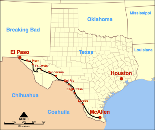
The title of this post is the most common response when I tell people we’re taking a two-week vacation in Texas. Anouk and I struggle to find vacation destinations that feature both good birding and biking. Texas promises to be a new experience. I’m going to bike solo from the north west to the south east for ten days, then meet up with Anouk for a few days of birding, then fly back from Houston.
The route
It starts in El Paso. Sing it with me:
Out in the West Texas town of El Paso
I fell in love with a Mexican girl.
Night-time would find me in Rosa’s cantina;
Music would play and Felina would whirl.
At the end, the protagonist turns into a murderer and is shot, dying in the arms of his love (an illegal immigrant). I’m married to a lovely Dutch woman, so this won’t happen to me. (The Pyrenean tour’s theme was Freddie Mercury and Montserrat Caballé’s Barcelona, which is a bit more of an upper and frankly a better ear worm.)
From there it continues along the border with Mexico, following the Rio Grande. I’m expecting huge empty stretches of ranches and deserts, with small towns in between. I’ll camp, but I’m not afraid to cheat and take a hotel here or there.
The equipment
Here’s what I’ve packed:
- camping gear: tent, mat, sleeping bag. No stove or pots.
- the Surly LHT. I like my bike, but I know it can be replaced. I made that clear to it when the index shifting failed near hilly Renfrew. In the Rockies I met Ryan, who has an image of his Raleigh Sojourn tattooed on his arm. That’s not me.
- the iPhone: partly because of the shitty selection of paper maps, I’m going to use Galileo’s offline maps. We’ll see how this goes.
- the usual stuff; clothes, tools etc.
I’m sure there’s a balance between too heavy and forgetting something crucial, but I have yet to find it.
The worries
All bike tours come with problems. In BC it was being distracted by stunning scenery. Jim and I struggled with forcing poutine and great beer down on La Tour de la Nouvelle France. And the Loire Valley? Hard to find fresh croissants on Monday mornings. Progress was slow in Holland because of the koffie en gebak. These things happen, but you get through.
My early concerns for this trip are:
- huge stretches with no facilities,. In BC there were a couple of days of 80km, here much of it is 100km+ without water. There may be some wild camping, which is new to me.
- I have just 10 days to cover 1300km if I’m to meet Anouk on time in McAllen. I’m incredibly out of shape, I’ve covered just 500km in 2014. I haven’t been on my touring bike for 4 months. I am physically not prepared.
- I’ve flown with my bike maybe a dozen times. I always worry the bike won’t arrive or will be severely damaged. This time I’m testing United Airlines.
Things like fast highways (80mph!), getting lost or running out of food don’t worry me much. I can fix flats, true a wheel or fix a chain if I need to.
More to come?
Maybe I’ll blog more about this, I’m terrible at that. I leave tomorrow.
Responses to the myths of winter biking
Posted by on December 21, 2013
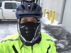 Friends and co-workers mean well when they tell me that winter biking is dangerous. Random drivers telling me to get off the road are less polite. Here are some responses to their most common concerns.
1. Why would you choose to bike in the winter?
I need to get around. The bus takes too long and I’m cheap. And I can’t drive (and if you want to know why, ask).
2. Winter biking is dangerous.
Winter biking’s safer than other modes of transportation.
Driving’s dangerous. From 2008-2012 in Ottawa drivers killed 11 cyclists, 37 pedestrians and 98 people in cars. Want to make the roads safer? Decrease driving.
Recreational activities? 25% of nonfatal recreational outdoor injuries in emergency rooms. An average of 29 people die every year by snowmobile in the Ottawa-Gatineau region.
3. Isn’t it cold?
Biking in the winter is like skiing or skating and warmer than waiting for the bus. Dress properly.
4. Bicycles have no traction.
If you think this it is because you have no experience.
A good cyclist with studded tires is more stable than a 2000lb car without winter tires. I’ve fallen less on bike than I’ve stopped to help stuck motorists.
Museum of Nature: it’s all about the parking revenue
Posted by on September 17, 2013
I went to the Public Information Session last night at the Museum of Nature. The original plan was to maintain a park on the west side of the building, now they’ve chosen to install a 96-spot parking lot. That’s different than what it was supposed to be.
Naively, I went there to talk to them about cycling aspects of their plans. There were none, and clearly they’d never done any research. They lied about reading the Ottawa Cycling Plan and there was nothing in their plans about biking at all. There were many myths shared (“nobody bikes in the winter”, “who bikes to a museum?”, “why you just walk 100m?”, etc). It was like we were back in 2005. Or at an MTO information session about widening the 417.
For more details on the history, etc, read the article I started at Developing Ottawa.
The story they tell
The story they tell is that they have more visitors than ever. They looked into everything, parking was their last resort (see page 9)! But they needed parking, so would preserve trees and hey, it was only 96 spots! It could have been a lot more!
What actually happened
Up to 2004, parking revenue covered about 0.7% of museum expenses (around $200k). They planned on that in the design and renovation of the museum (2004-2010).

This chart shows the annual parking revenue (in green bars) and the amount of the museum’s operating expenses offset by parking (in blue).
Then, the Conservative government mandated that museums generate more revenue (even though this museum’s parliamentary allocation is higher than ever). In 2011 and 2012, they created a ‘temporary’ lot on the west lawn and understood the profit potential (about $650k, 1.6% of expenses). At this point, they’re addicted to parking revenue. The 2013 budget depends on continuing with that revenue. They’d have to lay off their co-workers if they cut that.
This was always about parking revenue, it was never about figuring out their visitors’ transportation needs. They didn’t bother with a TDM study, surveys, investigating better transit or bike infrastructure, etc. That could only cut into their parking revenue.
Other costs to society (local green-space, maintaining roads, health and environmental costs, etc) don’t hit their bottom line. They have no incentive to care.
(All my numbers come from the museum’s annual reports, which are refreshingly easy to read.)
Give up.
To those in the community, here’s my suggestions to you: give up. You lost this battle a long time ago. Focus on something you can win.
There’s an obvious argument that a museum that promotes nature shouldn’t be enabling fossil-fuel guzzling motor vehicles. Nobody cares.
Update: I updated the map. I’d made a mistake and my map was misleading. I’d forgotten that Metcalfe was still there and extended the parking lot on the east side all the way to Elgin. Based on their published plan (in the map above), there’s a future appropriation of the road expected. It seems like a difficult negotiation to me. There’s another story there.
Understanding and fact-checking Councillor Hubley’s article on Complete Streets
Posted by on July 19, 2013

This is Terry Fox south of Maple Grove in Councillor Hubley’s ward. It is a multi-lane arterial that supports all modes of transport well, which is a Complete Street. He uses Terry Fox as an example of where he doesn’t want one. Does he understand what a Complete Street is?
Kanata South Councillor Allan Hubley wrote in his July 11 newsletter about why he voted against the July 5th Transportation Committee’s decision to support using Complete Streets when renewing Main St.
Councillors can vote however they like, but I feel they should understand the topic and use facts to support their position.
I’ll try to summarize what he wrote.
I think he’s saying that nearly all Kanata South residents drive and that should be our priority. He sees bicycling and Complete Streets as threatening that, so we should never have such infrastructure on arterials, particularly in his ward. He supports those arguments with:
- a incorrect understanding of what a Complete Street is
- a false assumption that an arterial can’t be a Complete Street
- a misunderstanding of the bicycle and Complete Streets infrastructure in his own ward
- statistics that are both fabricated and irrelevant
I dug a bit deeper into his text.
Fact checking
Here are Councillor Hubley’s exact words and my interpretation.
At the July 5 Transportation Committee, I voted against the building of a “complete street” on Main Street.
An example of a “complete street” is a road where you take four lanes and make it a two lane street by adding bike lanes and a wider sidewalk.
This is technically correct, but misleading. It suggests that the objective is to reduce driving lanes, and adding bike lanes and widening sidewalks is how is how that is done. Presumably he read the City’s definition: “Complete streets are streets that are designed to accommodate all of their special functions and serve all of the people who use them.”. Wikipedia’s referenced description is similiar. It says nothing about removing driving lanes or adding bike lanes.
I do not support the idea of taking away traffic lanes for vehicles in order to replace them with segregated bike lanes. It was important to oppose changing the streetscape on a North/South road corridor in a manner that would remove 300 cars an hour from the road.
Bicycles are vehicles. The Ontario HTA says so. I can’t think of anywhere the city says otherwise.
The plan does expect to remove capacity for 300 motor vehicles an hour (from 1200), but he’s not saying that that’s for only the six peak hours per week and drivers will be unaffected the other 138 hours a week. He also doesn’t say how many more cyclists (also vehicles) and pedestrians it will support.
Kanata South has a great network of bike paths and trails throughout the neighbourhoods behind houses, but not on the actual roadways.
This is not true. Kanata South does have both on-road bike lanes and off-road multi-use paths on roads like Terry Fox, Castlefrank and the Trans-Canada Trail. I don’t just make this stuff up, it’s quite clear from Google Maps.
Maybe it’s a Rorschach test, but if I disregard on-road biking what I see is some disconnected stringy bits, not the network of bike paths and trails he sees.
I support this type of cycling infrastructure, because it is safe and separates pedestrians and cyclists from moving vehicles. This is why I will never support a “complete street” in Kanata South.
Honestly, I don’t understand this. I think he’s saying he wants bikers and walkers to be separated from moving vehicles. Main St includes that, but he doesn’t want that for any part of Kanata South (arterial or not). I think he’s assuming that separating active transportation necessitates impeding motor vehicles.
I disagree with the idea of “complete streets” for arterials like Terry Fox, March, Carling, Eagleson, or Hazeldean.
Does he know that the city already has Complete Streets for different transportation modes on arterials? Beyond the example above (in his own ward), here’s a couple more local ones:
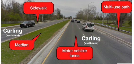
This part of Carling east of Holly Acres already is a Complete Street. It supports pedestrians, cyclists and drivers well. He mentions Carling specifically.
Here’s an example of an intersection of multiple arterials. I think it’s well done.
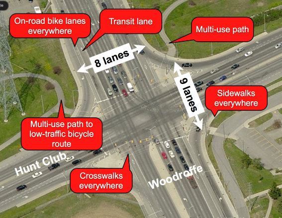
Large and fast arterials can be Complete Streets. This is an example in Ottawa of a very large intersection that supports all forms of transportation: driving, biking, walking and transit. Hunt Club is posted at 80km/hr, Woodroffe at 60km/hr.
Onward…
I also disagree that people from Kanata South will cycle downtown to their jobs 12 month a year if we choke off their ability to drive. The distance combined with our harsh climate, make it an unlikely option for the average family.
He’s disagreeing with nobody. I don’t know anyone who expects Kanata South residents to bike such long distances year-round. But the 2011 Origin-Destination Survey says that only 8% of trips within Kanata/Stittsville go downtown. And only some of them go by car. This is misleading.
The 2011 National Household Survey conducted by Statistics Canada found that almost 93% of Canadians commuted to work by car, and that most drove by themselves.
…
That number is wrong. From the 2011 NHS , 92.7% of people commute to work, but of them 74.0% drive and 5.6% are driven. That means that 69.1% of workers go by car. Plus not all Canadians actually work, so his 93% is more like 42%. I wish people wouldn’t make things up.
It’s also a red-herring. The Kanata-Stittsville region numbers from the O-D survey show that 63.7% of people are travelling to, from or within his district by car.
Expecting more from politicians
People can form whatever opinions they want, but it’s hard to consider them credible if they don’t have a basic understanding of the topic and support their position only by fiction.
Perhaps the councillor meant something different, a clarification is welcome. Comments from anyone are appreciated.
My 25km bike to work is now almost entirely on bike paths.
Posted by on June 16, 2013
People are amazed when I tell them that my 25km bike commute to work is almost entirely on bike paths away from cars.
A month ago I went to the opening of the O-Train multi-use path, which goes along the O-Train between Carling and the Ottawa River Pathway. Great, I thought, but I’ll never use it. But then I tried it as a temporary construction detour from my old route. How nice! Then I started rolling the numbers.
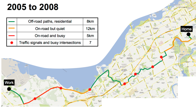
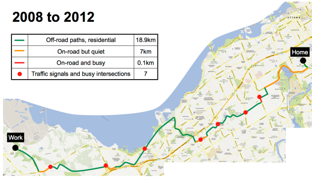
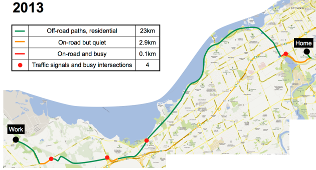
A lot has changed in Ottawa since I started biking to work. The infrastructure is improving. Here’s how it went for me:
2005: I challenge myself to ride in just one day, it seems an impossible feat. The western part of Carling is really bad. People think I’m insane.
2008: The City paves the shoulders of the western part of Carling and the NCC Watts Creek Pathway is paved. Most of the route is easy (green) except for links. Intersections are a pain as the lights favour drivers, some have 3 min waits.
2009: I start biking to work in the winter. I get into the habit of just taking Carling all year round which is faster. Crazy.
2010: Major construction on Carling so I start taking the paths to avoid congestion with cars. I’m much more relaxed.
2013: The O-Train path is installed which makes the route flatter. I’m now down to just two traffic lights going to work, three coming back. There’s almost no road so I have to deal with pretty much nobody.
Here’s a table that shows how the portion of the route is now residential and paths.
If I was willing to add 10 mins to my trip I could get an entirely green route. It involves a bit of crushed-stone path and a few lights (some which are per-only).
These changes make a big difference for people on this route, but there are changes in other places that also affect many other people. Some examples are the Laurier Segregated Bicycle Lane, sharrows on Lyon, the bridge over the Airport Parkway. I know there’s lots more coming over the next few years. The Fifth/Clegg Bridge and the Donald St. Bridge are important projects that will convince new people to take up biking.
Yes, it’s getting better. But we need to keep up the pressure.
Lansdowne modal share numbers – there’s a long way to go.
Posted by on March 20, 2013
As I’d written in the past, the transportation plan for the Lansdowne Park renewal relies on many people leaving their cars at home. The breakout of that modal share is quite aggressive.
When figuring out trends, it’s important to try to measure the same thing (a 67s hockey game in this case). And find a baseline, which they’ve done by doing a survey of attendees of a game in March 2012. This is good news, they got the data before the games moved out to Scotiabank Place during construction.
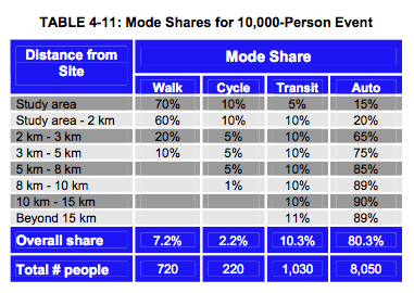
I’ve compared them to the original June 2012 transportation plan’s expectation for modal share. I used the numbers for the 10,000 attendance; I know that’s a bit off the 8600 people who attended this 6s7 game, but it is the closest thing available.
How far off are we?
Here’s the overall share, you can see there’s considerably more people arriving by car than should be in the future, according to the plan:
Let’s look closer at both the sustainable parts (walk, bike, transit) and cars (unsustainable):
We need to quadruple the number of people who walk, bike and take transit to achieve the goals. Note that pretty much nobody (0.3%) of people biked to that 67s game, and March 2012 was a great month to bike. Imagine January or February…
Weirdness for people arriving by car
What one wants is to have fewer cars, but not necessarily having fewer people arrive by car. Ideally, all cars would be stuffed to the gills with as many people as possible, and based on these numbers that’s what seems to be happening.
The relevant count is called People Per Vehicle (PPV). The expected number is 2.5, but right now they’re exceeding it at 3.1. The number of cars is actually lower now than what the plan calls for, so on the surface it looks pretty good!
Here’s a back of the napkin calculation: in March 2012 there were about 2400 cars and 2200 on-site spots. The new plan is for 2760 cars, but with only 1000 on-site spots. Where will the rest go? They will wander the streets, searching for parking spaces, making it less desirable to bike or walk.
So what’s the problem with biking?
Some things have been said about how to deal with transit (adding free shuttle buses) and reducing number of cars (providing access to remote parking lots, with said shuttles).
But nobody’s said anything about how to get so many people to walk and bike and no funding’s been secured for a new bridge at Fifth/Clegg. No new bike lanes have been proposed by the city. It’s supposed to happen like magic.
And, congestion is going to get worse. Biking will become even less desirable when there’s more motor vehicle traffic.
Notes on the data sources
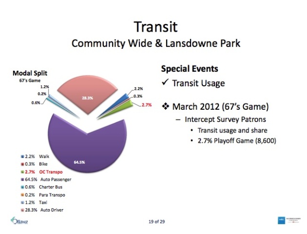
The modal share measurements from the March 2012 67s game was presented on February 28th 2013 at the Lansdowne Transportation Advisory Committee called “Lansdowne Monitoring Plan – Implementation”. The presentation is a little confusing, but you can see it referenced on slide 19. It breaks out the modes into a greater resolution, so I did some consolidation to match the original transportation plan: transit is the sum of OC Transpo, Charter Bus and Para Transpo. Taxi got merged into Auto Driver. Here’s the slide that shows the measurements.
The modal share estimates for the plans are in Table 4-11 in the Lansdowne Revitalization Transportation Plan from June, 2010 (the latest).
There you go.


