Alex Bikes
Ottawa bike politics.
QED crossings out of sync with NCC
Posted by on November 28, 2011
It is this map that got me really concerned:
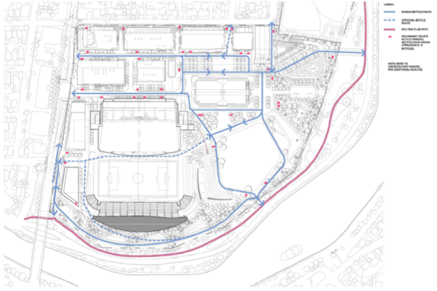
Figure 1: Bicycle routes as described in Changes in Lansdowne Partnership Plan Implementation Status Report (August 2011)
Sometime since the summer of 2010 they’ve dropped all the linkages to the path that runs on the eastern side of Queen Elizabeth Drive!
This is a considerable step back. Cyclists who would want to leave from the park to go home along the NCC Rideau Canal path would want to exit straight to the west, and then cross Queen Elizabeth Drive and get on the pathway. This was on older diagrams, too, like from June 2010:

Figure 2: Diagram showing planned exit point and crossing of Queen Elizabeth Drive, page 169 of Transportation Impact and Assessment Study and Transportation Demand Management (June 2010)
Cyclists leaving the park would want to exit directly to the west, cross QED, then head home (north or south) on the path next to the canal.
Now, they’d only be able to exit to the western path. The east and west sides are quite different, as the west one ends at Fifth Ave. on the north, and just under the Bank St. Bridge near Queen Elizabeth Place.

Figure 3: Local paths
Let me explain why one wouldn’t want to use either crossing.
The problem at Fifth

Figure 4: Diagram showing the problems of crossing QED at Fifth Ave. to get from Lansdowne to the NCC path that continues north.
It is possible to cross at Fifth Ave, but the trajectory requires crossing both QED and Fifth Ave. on a diagonal. The depressions in the curb on the east side of QED are not placed properly, which makes this intersection difficult. This is also expected to be the landing spot of the Fifth/Clegg bridge.
The problem at Queen Elizabeth Park

Figure 5: Diagram showing the problems of crossing QED at QEP to get from Lansdowne to the NCC path that continues south.
Southbound, the path also ends at an awkward angle, and requires the cyclists cross either directly diagonally across Bank St., or do a jog to get in line with queued traffic. Either way, it is an awkward manoeuvre.
Is it a bike route or not?
Some people didn’t think Sylvia Holden Park was a park, so nothing can be taken for granted.
There’s two organizations that think that the western path is an NCC cycle route:
- Google Maps (which is wrong about lots of other stuff… more about that in another article)
- the 2011 references of the Lansdowne plan says it is part of the Ottawa Cycling Plan
The following organizations I consider more authoritative do not think this is a bicycle route:
- the Ottawa Cycling Plan (looking at both current and future implementation)
- the NCC bicycle map (either of them)
- the Ottawa bicycle map (any of them)
- the NCC’s Rideau Canal Corridor Pedestrian Crossing Study (June 2011)
I have a bit of exposure to NCC and the City of Ottawa working together. It is definitely better (as evidenced by the Bay St/Wellington construction), but working out multi-jurisdictional problems is still hard. The whole project would be a lot easier to just not have to deal with the NCC. So I think they just chose not to.
Synchronization with the NCC’s plan to rebuild intersections
Back in 2008, the NCC started a study to review how pedestrians crossed both Queen Elizabeth Drive and Colonel By Drive. They got some flack for being slow in delivering it, but the June 11, 2011 final release is well done. The problem was that with increased traffic, these driveways were becoming increasingly difficult and seemingly dangerous to cross.
Certainly the schedules of the authoring of this document and development of the Lansdowne plans overlaps, but the Lansdowne plans never say anything about this. And here’s the entire reference the NCC report has to Lansdowne, on page 83 (the last one):
“It is understood that the outcome of the current Lansdowne Park redevelopment may impact traffic and pedestrian patterns along Queen Elizabeth Drive. The NCC should monitor the projected/actual changes to these movements as this redevelopment progresses. “
The report goes through all the intersections and makes recommendations on what to do. In most cases, it is to do nothing, and there’s this predilection for roundabouts.
But let’s look closer at what the NCC says about the ends of this path.
NCC’s preferred option at Fifth

Figure 6: NCC's preferred option for reconstructing Queen Elizabeth at Fifth Ave.
Notice how there’s no mention of the path as it enters into the circle.
NCC’s preferred option at Queen Elizabeth Place

Figure 7: Preferred option for intersection on Queen Elizabeth Drive at Queen Elizabeth Place
Again, there’s no consideration for how the path would enter into the circle (and the path isn’t even drawn in).
Conclusions
The city should meet with the NCC to consider an enhanced intersection at the exit of Lansdowne, and do a complete route analysis.
And the more I get into this, the more I think they should put together an actual bicycle report.

Alex, don’t be silly now. They can’t have all those crossings or it will slow the traffic on the driveway down.
Pingback: A summary of the Lansdowne bike situation, an open house, what’s next… « Alex Bikes